Nature’s Photo Shooting tours
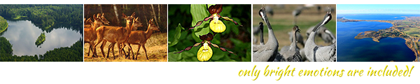
Belarus is a very beautiful country, that harmoniously combines the most interesting cultural and historical heritage with wonderful gifts of nature. Ancient forests, beautiful lakes and fields are the most attractive to the eye of a photographer. Because of its natural landscapes Belarus is very often compared to Switzerland. Belarus is the Motherland of white storks, which population here is great. And European aurochs, the last ones in their kind, that inhabit in Belavezhskaya Pushcha, are the visit card of the country. For sure, nature's photo shooting in Belarus will enrich your collection of impressive photo pictures.
|
Photo Shooting in BELAVEZHSKAYA PUSHCHA
(forest, UNESCO heritage)
|
BOOK NOW
|
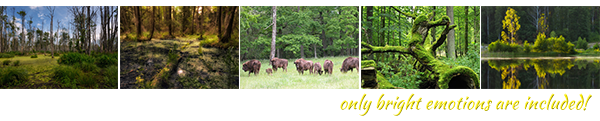
Belavezhskaya Pushcha is called after Polish settlement of Belavezha (Białowieża). The Pushcha is the territory of a relict forest, which in old times covered most of Central Europe. Gradually the forest was cut down, but on the territories of Belarus and Poland it was saved. Noteworthy, that the Pushcha was protected by its owners since the Middle Ages. So the Grand Duke of Lithuania and Polish King Jagaila in 1406 prohibited hunting big game here. Today Belavezhskaya Pushcha is under the protection of Belarusian state and is the vast reserve of flora and fauna, where hundreds of rare and endangered species of birds and animals live and breed. The air of Belavezhskaya Pushcha is filled with the fragrance of flowers, pine and spruce resin, fern, wild rose, the smell of forest berries and mushrooms. Giant oaks, ash-trees, maples, pines and spruces are the great heritage of old times. Some of the trees are of 450-530 years old and have the height of 40 meters. The king of that forest is European aurochs, whose population here is the only one in the world. The animal is the symbol of strength and power and nobility, all that connects present days’ Belarus with the former power and glory of the Grand Duchy of Lithuania. That’s why you can often see aurochs’ image as a logo of Belarusian sport teams. Walking the Pushcha’s trails, you can meet the family of aurochs in natural habitat. Also you can found here deer, wild boar and other hoofed animals, lynx, marten, polecat and even a wolf. Near rivers and lakes you can meet otter, mink, beaver and other forest dwellers. In 1992 Belarusian part of Belavezhskaya Pushcha was included by UNESCO in the List of World Heritage. Today Belavezhskaya Pushcha is the museum of nature and is open for visitors. For professional photographers they organize special routes, where you can take unique and extraordinary photos of wild and rare European nature, which looks now almost as it looked many centuries ago. Belavezhskaya Pushcha is also the Residence of Belarusian Santa Claus (Father Frost). His estate is located near the highest spruce (natural Christmas tree) in Europe. Be sure, your journey to Belavezhskaya Pushcha will become picturesque and unforgettable!
|
Photo Shooting in BEREZINA BIOSPHERE RESERVE
(the Ramsar site)
|
BOOK NOW
|
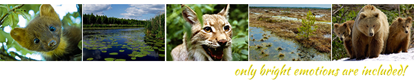
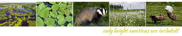
Berezina Biosphere Reserve is situated in the north of Belarus and is the largest swamp area in Europe. Berezina Biosphere Reserve takes its name from the Berezina, the longest river in Belarus, and together with the Western Dvina, the Svisloch, the Druts and the Dnieper it creates the water system, which has been connecting the Baltic Sea and the Black Sea since the 10th century and was worldwide known as the most important trading route “from the Vikings to the Greeks”. The square of Berezina Biosphere Reserve is 852 sq. km. and contains endless forests, large swamps, meadows, rivers and lakes. It is the vast territory of wild nature! Here you can find brown bear, elk, wolf, lynx, European aurochs, deer, roe, beaver, hare and many others. The most significant dweller of the Reserve is golden eagle (one of the largest eagles in the world), whose wingspan up to 2.4 meters. The other rare birds here are black stork and gray crane. In spring and summer seasons the Reserve organizes special tours for observation of animals and birds in their natural habitat. In 2010 Berezina Biosphere Reserve was included in the list of Ramsar sites as the most important swamp area for birds protection. The other routes for tourists are: walking and bicycle tours, safari tours, horse riding, kayaking and others. For photographers they have the observation deck of 12 meters height to take excellent panoramic photos. For children it would be interesting to go by the Trail of Discoveries of the arboretum, play at the rope town or visit the zoo. Hunting tourism is also developed in Berezina Biosphere Reserve, it is organized beyond the boundaries of the Reserve and within a special hunting zone. They support foreign hunters with all necessary documents. Visit Berezina Biosphere Reserve and enjoy the wonderful opportunity to touch the real nature and breath the pure air!
|
Photo Shooting in the National Park
“THE BRASLAW LAKES”
|
BOOK NOW
|
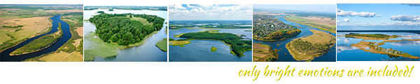
The Braslaw Lakes is the water area of Belarus of more than hundreds of lake and river islands, the significant portion of the country’s islands. The Braslaw Lakes are situated in the north of Belarus (Vitebsk region). They were created by the last glacier more than 15,000 years ago. The boulders left by the glacier can be found here and there on the islands. The biggest boulder is on the western part of the bank of the Strusto lake and has the size of 4.5x4.5 meters and the mass about 40 tons. The territory of the Braslaw Lakes in the 10-13th centuries was on the route “from the Vikings to the Greeks”, that’ s why some of the nearby settlements keep the history of those times. So in the village of Maskovichy the archeologists discovered a Viking settlement and a place of a significant number of runes and images dating to nearly 900 years old.Today the Braslaw Lakes area is a well developed tourist region with a number of sand beaches and purest lake water.
The Islands in the Braslaw Lakes:
The Chaichin Island
The second large island in Belarus is the Chaichin Island. It has the square of 1.6 sq.km. It is situated in the centre of the large and the picturesque lake Strusto (the Braslaw Lakes area). Till the lowering of water level in the 1930s its northern part was a separated isle called the Yurkovo. The Chaichin, the Yurkovo and the Shova created a small archipelago, where the village Strusto Island was situated. In 1931 the population of the village was 27 people, who lived in 6 houses. Today the island is uninhabited. The beauty of the Chaichin Island is in its meandering coast line with deep bays, narrow isthmus and the sandy beaches. On the island there is a small inland lake, which for ages has been rich for crucians. The hills of the Chaichin are replaced by lowlands, covered with pine forests, juniper bushes up to 3-4 meters in height, and a birch grove, where atypical for Belarus Karelian birch grows. You can see the Chaichin Island and the other 7 islands of the Strusto lake from the observation desk “Mayak” (lighthouse)
The Turmas Island
The Turmas Island is situated in the lake Snudy (the Braslaw Lakes area). The Snudy lake has been one of the most fish. Of a special demand were pike, smelt and selyava. Till the end of the 19th century they caught a great number of crayfish, which were delivered in wagons even to Prussia. The Turmas Island was inhabited by three families. They reached the mainland on boats, and on foot and on sleigh in winter. Sometimes, in the off-season it was impossible to reach the opposite shore on thin ice, and the islanders for a few weeks were cut off from the mainland. You can see the Turmas Island and the other 11 islands of the Snudy lake from the observation desk “Mayak” (lighthouse).
The Castle Island of the Drisvyaty lake
The Castle Island of the Drisvyaty lake (the Braslaw Lakes area) was known since the 11th century. In the times of the Polotsk principality there was a settlement for nearly 400 people on the island. The island with the fortified castle on it many times was mentioned in chronicles of the Grand Duchy of Lithuania in the 15-16th centuries. Near the castle there were a landlord’s yard, a market place, three streets and a church. The island was connected with the mainland with a help of two bridges. In the 17th century the castle was ruined. For many years archaeologists had been working on the island, studying the cultural stratum of the settlement of the Polotsk principality´s and the Grand Duchy of Lithuania´s periods, and during the excavations they discovered many interesting finds, which nowadays are kept in the Museum of Braslaw. The Drisvyaty lake is the area of relict animals, who survived since the last glacier. So a tiny amphipod crustacean Pallas according to its form reminds a shrimp, but its length is just 1.5 cm. The crustacean inhabit on rather a big depth, where the temperature is equal during the year.
The Castle Island of the Ikazn lake
The Castle Island of the Ikazn lake (the Braslaw Lakes area) in the end of the 15th century was owned by Braslaw headman Jan Sapega, who started the construction of fortified castle here. Defensive walls of the castle, built of stone and brick, clay ramparts with wooden structures and two towers towered up above the wooden buildings of the town. In the 16th century the castle was the center of thelarge possessionsof the Sapegas in Braslaw. The significant part of the island was occupied by the under-castle, surrounded by an earthen rampart. Near the walls of the fortifications there was an artificial pond for fish, coming from the lake. The island was connected with the mainland with a help of a floating bridge, built on special shuttles that in case of danger could be quickly hidden under the water. The castle was destroyed in the beginning of the 18th century during the North War. There is a legend that says that the enemy couldn’t enter the castle for a long time and were ready to raise the siege, but suddenly a cow passed the hidden bridge and then enemies broke into the castle. The other story tells us about the buried treasure of the 17th century that lies at the bottom of the lake not far from the Castle I
The Monastery Island
At the beginning of the 19th century on the Monastery Island of the Nespish lake (the Braslaw Lakes areas) were head the sounds of the church bells and the masses were served. Braslaw friary with a church and dwelling buildings were built on the island in the 15th century. The lake and the nearby settlements belonged to the friary. The island was connected with the mainland with a help of two bridges. Near the main bridge there was a hostelry. The pilgrims came to the island to pay homage to the miraculous icon of the Virgin Mary of Braslaw, Lady of the Lake and the patroness of all Braslaw area. Becauseofhugequantityof people the masses were served in the field, right on the bank of the lake. In 1832 the monastery was burned in the terrible fire, but the icon saved. Accordingtothelegendit was found on the nearest Saint Island, where the Saint Cross had been installed since the existence of the monastery. Theiconwasbroughtfrom the Saint Island to the altar of the Braslaw Catholic church, where you can see it nowadays. On 24, August Braslaw celebrates the day of the Virgin Mary of Braslaw, Lady of the Lakes.
The Du Island
The Du Island is situated in the lake Asveya in the north of Belarus (Vitebsk region). It is 5 sq. km. and is the largest island in Belarus. The ancient name of the island was left by the Finno-Ugric tribes and meant "lake". The other version says there was a Baltic settlement on the island with its own parish and the church of Virgin’s Nativity. From the Baltic languages of those times “Du” was translated as “two”. There are two mountains on the island: Gorodok and Perunovka. Till 1970 the island was inhabited. There were nearly 50 houses, a shop, a farm, a club and a diesel substation here. People got to the island on boats, on foot or on a sleigh on the ice, and after the WW2 on the ferry. Today the island is a wild one. Only old cemetery reminds of human dwelling here. The island has been recognized the nature reserve, inhabited by wolves and elks. It has become a good place for watching birds.
The Ghost Island
Floating island is the other sight of the lake Asveya. Being not attached to the bottom it moves slowly along the surface of the lake with the average speed of 1-1.5 km per hour, depending on the wind. The locals called the island a “Master”. The form of the island reminds a nest. Instead of soil the bottom is done of bound algae, roots and branches. Walking on it is possible, but dangerous. Flexible trees and shrubs are places for birds’ nesting. Every year the island grows in size, because when floating it gathers everything on its way, converting the water into swamp. Fishermen, apparently in revenge for the ruined network, called this island a “Ghost”. They say that at night on the deck of the branches a weightless and rather nervous ghost is walking and screaming, that frightens people and fish. According to fishermen, the fish here indeed do not bite. But the locals say that the “ghost” in reality are muskrats, living here.
The Castle Island of the Myadel lake
The ancient town of Myadel (or “Woodland” in the language of the Baltic tribes) appeared in the island about the 10-11th centuries. It was surrounded by tall wooden walls (later the walls were made of stone) to keep the defense from the siege of crusaders. In troubled times the people from other isles could find a protection behind the well-fortified walls of Myadel. However, in the first half of the 15th century the plague forced people to leave the prosperous town. Later the town was rebuilt anew on the mainland. The Castle Island was connected with the name of Bona Sfortsa, the Grand Duchess of Lithuania and the Queen of Poland, who received the local areas with the lake as a present from her husband Zhihimont (Sigismund) the Old. According to the legend, the contemporary Myadel used to be surrounded by three majestic castles, every one of which was built on a separate isle. They were called the Myadel, the Naroch and the Myasto isles. They say the Myasto isle was the permanent residence of the Queen.
The Jew Island
The Red lake in the Palesse, which in different times was called the Prince lake of the Jew lake, is shrouded in legends and stories. One story tells about a Jew, who lived nearby the lake and maintained his own tavern. One of the noble princes fell in love with the daughter of the Jew and offered to build a castle on one of the five islands. The best builders of Slutsk obeyed prince’s order, but the spring flood didn’t spare their efforts and destroyed the strong placing. Since that time the lake was called the Jew. The other legend says, that in the castle the prince Olelkovich, one of the Slutsk princes, was imprisoned. The older brother hated the younger, and sent him to the island. The death to the prisoner was brought by the very flood that destroyed the castle in spring.
The Stefan Batory Island
Fortified in old times island, with which the history of Disna settlement began, lies at the confluence of the Western Dvina and the Disna. During the times of the Polotsk principality the island was called Kopets, that meant earthen fortifications. In the second half of the 16th century Stefan Batory, the Grand Duke of Lithuania and the King of Poland, started the construction of the fortified castle here. The island, along which the castle with nine towers grew up, used to be called the Old Castle Island. During the 16-18th centuries the castle played the role of a fortified fortress and a customs house, where trading goods were being checked. There were storehouses on the island. They were full of lard, bread, wax, honey and fish - all the goods, that Disna merchants brought to Riga. Having survived after the war of 1812, the castle was totally destroyed by the fire in 1882. Today the Stefan Batory Island is covered with castles ruins. By the way, right near the island, in the place of the rivers confluence, there is the middle of the Western Dvina.
|
Photo shooting in the National Park
“NAROCHANSKY”
|
BOOK NOW
|
The National Park “Narochansky” is the resort area of Belarus famous for its healing mineral springs, pure lake water and very picturesque landscapes. It is situated in the north-west of the country and is a part of Belarusian Lakeland. There are 43 lakes on the territory of the Park. They were created by the last glacier 15,000-20,000 years ago. The pearl of the park is the Naroch lake, that is the largest lake of Belarus. Its square is 79,6 sq.km. About 48% of the park is covered with picturesque pine and birch groves. The flora is rich of variety of mosses, lichens, mushrooms and algae.The most beautiful Belarusian orchid “lady's-slipper” is growing here. You can find here European red deer, wild boar, elk, roe, raccoon dog, badger, marten, mink, otter, beaver, muskrat and other animals. Nearly 35 species of fish inhabit in the waters of the park, that’s why the Park is very attractive place for fishermen. The camping is also very popular here. There are 16 tourist equipped tourist parkings on the banks of 9 lakes. The Park offers walking and bicycle tours, kayaking, yachting, hunting, fishing, diving and others. For photographers it will be interesting a sky walk on a helicopter to take panoramic photos from the height of the bird's flight.
|
Photo shooting in the National Park
“PRIPYATSKY”
|
BOOK NOW
|
The National Park “Pripyatsky” is the area famous for its wild Belarusian nature and impassable swamps, that have no analogues in the world. According to the western tour operators the National Park “Pripyatsky” can easily compete with the famous National Park “Everglades” in Florida, USA. Indeed it is difficult to collect in one place such a diversity of animals, birds, plants, meadows, forests, wetlands and water bodies, which are available in the National Park “Pripyatsky”. The Park is situated in the south of Belarus in the center of the Palesse swampy lowlands, which are usually called “the lungs of Europe”. It is a paradise for bird watchers and for the lovers of birds. The Park organizes special tours for tourists and photographers, where they can observe birds and animals in their natural habitat. For the observations they use water routes, pedestrian or road routes, ambush, special observation decks with the opportunities for photographers to take pictures of wild life. The rich hunting and fishing grounds of the Park attract hunters and fishermen from all over the world. During the tour you’ll also get known with the unique customs and traditions of Belarusian Palesse.
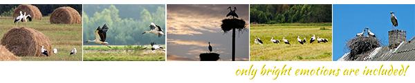
For sure, you’ve heard much about flamingo lands, but you cannot even imagine that Belarus is the land of large population of white storks! White stork in Belarusian is called “busel”, that’s why busel is the symbol of the country. Busels nest in Belarus from March till September. According to scientists, they come here from African Sahara Desert. To see the beautiful royal storks and take their photos you don’t need to visit special area of Belarus, just take a car and go on a highway to the wide expanse of fields: the storks are everywhere! Busels like to nest on rooftops of the village houses or on poles of electricity transmission lines, that’s why it’s a usual phenomenon here. For ages the locals have known, it is a great luck and grace, if busel nests on the roof of your house, that’s why this bird here is in great reverence. Also, every child here knows, that stork brings children, for this is one more reason to take care of the stork’s population. August is a special time for taking photos of busels. When the harvest time comes, you can see hundreds of storks, walking in the freshly cut fields near combine-harvesters. White storks are very friendly birds, and here in Belarus we know it very well. Come here and see it with your own eyes!